|
|||||||||||||||||||||||||||||||||||||||||||||
|---|---|---|---|---|---|---|---|---|---|---|---|---|---|---|---|---|---|---|---|---|---|---|---|---|---|---|---|---|---|---|---|---|---|---|---|---|---|---|---|---|---|---|---|---|---|
BACKGROUND:
|
|||||||||||||||||||||||||||||||||||||||||||||
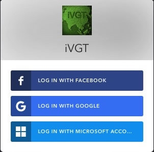
NEW IVGT TRACKING SYSTEMOverall goal is to operate computer and mobile applications ( Android and iOS platforms) for international Vetiver site location tracking app. • This application uses the authentication of Google, Facebook, and Microsoft accounts to identify the user. • It supports permission controsl to enable registered users to set up new sites and modify where necessary existing information, allowing for site deletion only by administrators. • Vetiver grass is mapped with satellite image or street map as background. • User can share information on social media and there is public viewing of sites and data
|
|||||||||||||||||||||||||||||||||||||||||||||
KEY ACCESS INFORMATIONIVGT website (computer access to Tracking System) iOS app - AVAILABLE from Apple app store Feedback and Discussion relating to tracking app (TVNI Forum) NOTE: THIS ONLINE TRACKING SYSTEM STARTED OPERATING IN NOVEMBER 2018 AND THEREFORE, AT THIS TIME, HAS VERY FEW VETIVER SITES ENTERED (with the exception of Thailand) . USERS SHOULD REMEMBER THAT THERE ARE TENS OF THOUSANDS OF YET TO BE RECORDED SITES. WE ENCOURAGE VETIVER USERS AND OTHERS TO REGISTER AND VIEW EXISTING AND ENTER NEW SITES |
|||||||||||||||||||||||||||||||||||||||||||||
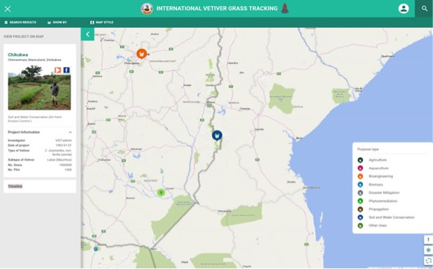
VIEWINGWhen browser opens global map is shown. Clicking on a vetiver site (colored circle on global map) shows details of site including purpose, species, plant numbers, and photo updates.
|
|||||||||||||||||||||||||||||||||||||||||||||
|
|||||||||||||||||||||||||||||||||||||||||||||
 |
|||||||||||||||||||||||||||||||||||||||||||||
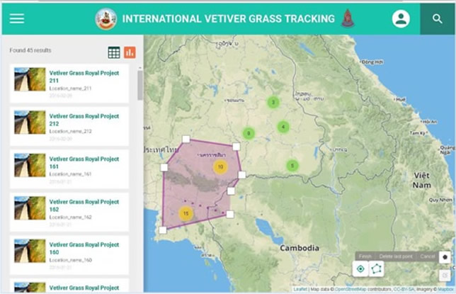
| Each project is shown by a different pin color, in this case projects are shown by "purpose of use" - orange - bio-engineering, and blue - soil and water conservation. Other categories include "vetiver species" or by "planting method". The legend is visible by clicking "!" and automatically changes to reflect the category chosen. In this caset the blue pin was selected, showing "Chikukwa, Zimbabwe" in the side bar. | |||||||||||||||||||||||||||||||||||||||||||||
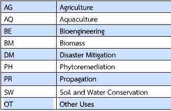
MAIN USE CATEGORIES
|
|||||||||||||||||||||||||||||||||||||||||||||
|
|||||||||||||||||||||||||||||||||||||||||||||
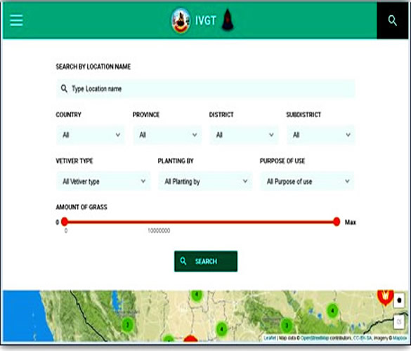
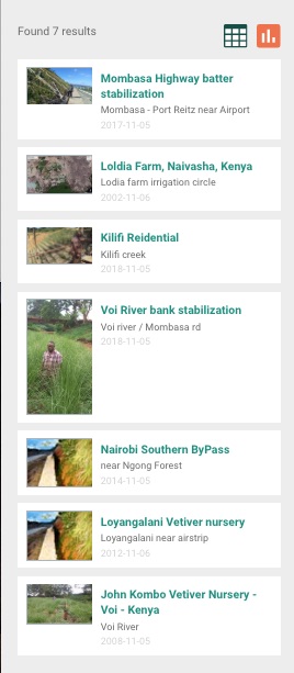
SEARCH ENGINE:Search by: • Country, Province, District and sub district • Filter by The "Search" button will bring up this screen. Type in a familiar site name will under the location name will bring up the vetiver site. A "Country" name will list all sites in a country.
|
|||||||||||||||||||||||||||||||||||||||||||||
|
|||||||||||||||||||||||||||||||||||||||||||||
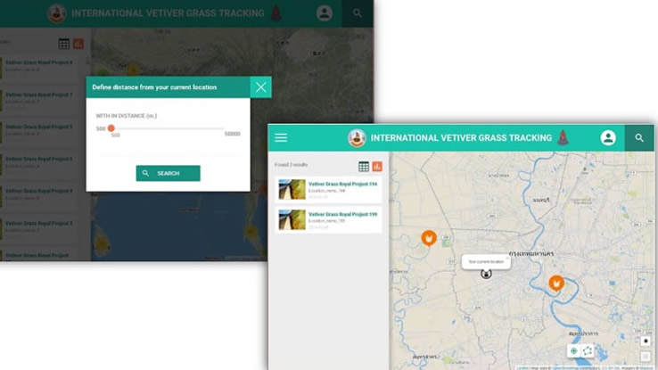
SEARCH VETIVER SITE (alternative method 2)Define define the boundary to find vetiver site. - click on button at bottom right of global map.
|
|||||||||||||||||||||||||||||||||||||||||||||
|

| User | Area of oper-ation | Add new site | Remove site | Edit site descri-ption | Add update | Edit update |
View | Approved by |
|---|---|---|---|---|---|---|---|---|
| Administrator | Global | X | X | X | X | X | X | |
| Surveyor | Global | X | X | X | X | X | Administrator | |
| Investigator | Country of Residence |
X | X | X | X | X | automatic approval at registration | |
| Non -registered | X |
There are 6 administrators appointed to administer the system world wide.
There are a limited number of Surveyors who can operate golobally. They act as moderators and will report issues to Administrators. Surveyors will only be approved if known by Administrators or who are known to be reliable and active Vetiver System users and contributors to the Vetiver knowledge base.
MOST NEW REGISTRANTS SHOULD REGISTER AS "INVESTIGATOR"
If you register as an Investigator you will automatically be approved.
NOTE WE FOLLOW WIKIPEDIA RULES - "RESPONSIBLE EDITING" FOR THE COMMUNITY GOOD !!!
FIRST "REGISTER"!!
Click on this button (top right menu bar on map) ![]() and fill in required information
and fill in required information
Investigators receive automatic approval, Surveyors will receive email notofication.
LOG IN
AFTER LOG IN THIS SCREEN - "My Sites" - opens
This screen lists project sites that you may have entered. You can view "My sites" in detail or edit ia site (Only Administrators can delete a site) by clicking on the appropriate "blue" button.
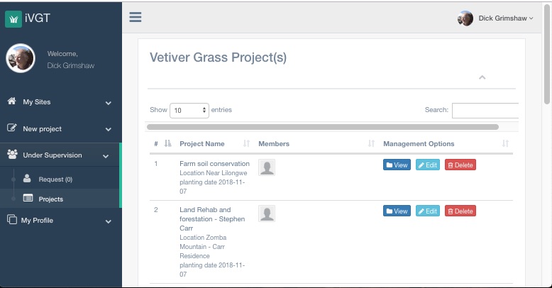
You can also open up the left side menu tab "under supervison" that allows you to view or edit in detail all the projects in the country when registered as an investigator, and globally if you are a supervisor.
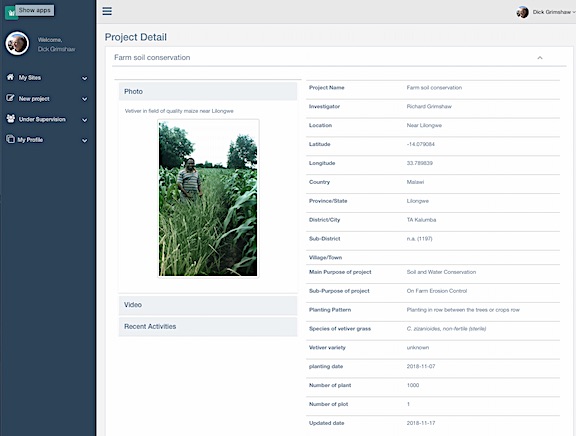
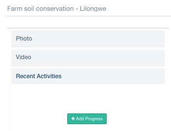
This is the screen that you see if you "view" a project site
"ADD PROGRESS"
NOTE: AT THIS TIME FIREFOX BROWSER WILL NOT ALLOW IMAGE UPLOAD. CHROME, SAFARI, AND WINDOWS BROWSERS WORK. THERE ALSO APPEARS THAT THE ANDROID APPWILL NOT UPLOAD PHOTOS to"ADD PROGRESS"
Under the "view" screen you can "add progress" including text and images under "Recent Activities".
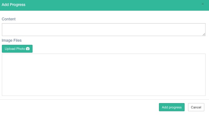
Note: You can upload three images under each progress event update. Text cannot be entered without an accompanying image.
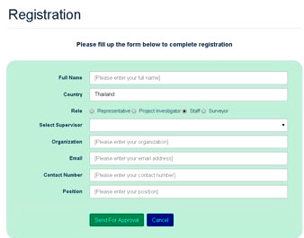
ADDING A NEW PROJECT OR EDITING AN EXISTING PROJECT
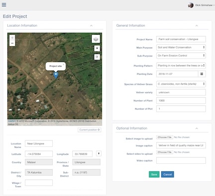
This is the "new project"/"editing" screen. Most of the fields have to be completed. If you fail to fill a screen you will be prompted to do so! Some tips: If you are in the field and have internet connectivity use your smart phone to complete the screen. By using a smart phone you can accurately locate your postion by clicking on the "current position" button located just under the satellite image. Under "project name" field include a word that will later help you search for the site. If you know exactly the number of plants planted provide that figure, otherwise make a rough estimate (approx 600 plants per 100 meters of vetiver hedgerow.). If you choose to upload a photo it will show on the "site view" screen. In this version there is no field for "notes" . However you can use "image caption" or "add progress" text boxes for short notes.
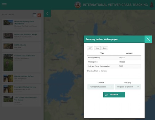
SUMMARISING DATA
The app has a feature, for both registered and non registered users, that summarizes data based on various settings of the search engine. In this example the country "Kenya" was selected and by clicking on either button at top right of this image, collective data shows as in the secnd image. Note in this example two of the sites show generic images because photo images were not uploaded.
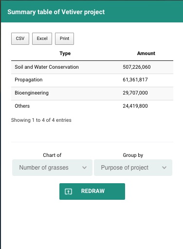
Below is a similar summary for Thailand the numbers show the number of vetiver plants planted for under four categories of application.
QUESTIONS & ANSWERS
Q: What is the best way to start using the tracking system?
A: (1) READ the Tracking Guide at https://www.vetiver.org/TVN_tracking/TVN_track3.htm
(2) READ the Q&A below
(3) Before using it for serious data input get to know how it works. In other words try it our - best on you computer if you have one - open https://ivgt.ldd.go.th/vetivertrack/. If you only have a smartphone go to Play Sore for android and Apps Store for iOS (Apple) and search for IVGT and install. On the whole it works pretty well but there are some problems that in the beginning can be a bit frustrating. Remember you don't have to register to view the Global map and its sites (click on the circles to see some basic information). When you have "discovered" this aspect of the tracking system app then register. Once registered you can see more data, and add sites and edit sites.
Q: Can I register as an "Administrator"
A: PLEASE do NOT register as an administrator as your request will not be accepted. There are only 7 administrators for the whole system and these are by appointment only. If you want to be able to view in detail and to edit sites globally, you should register as a "surveyor". If you want to just work in your country of residence register as an "investigator".
Q: My country has blocked Google, Facebook and Microsoft so I cannot register and log in. Is it possible to have a more standard type registration?
A: This matter will be taken up with the operators of the tracking system.
Q: I work in China and cannot access the main IVGT site - it has been blocked. Why should this be? Note: I can access the TVNI
A: Developers will respond.
Q: Why can I not upload images under "Add Progress"?
A: This is a browser issue. Unfortunately if you use Firefox images will not upload. Will upload using Chrome, Safari, and Internet Explorer. It also appears that at this time one cannot "add progress" when using the Android app. No reports on iOS app capability in this area.
Q: How can I show before and after photos for a particular vetiver site.
A: The best and only way to do this is under "add progress" button. Just make sure that before you add the images that you have sized them to around 50 kb.
Q: How many photos can you add under "Add Progress"?
A: Each time you "Add Progress" you can add up to three photos. You should add all three at the same time other wise if you add one at a time they overwrite each other.
Q: Currently site data fields do not include a text box for comments. I hope such a box will be included in the future. What can I do in the meantime?
A: The only place you can currently add comments is under "Add Progress". Note you have to add an image as well, otherwise the text will not be accepted.
Q: Images up load slowly. Can up load be accelerated?
A: Reduce image size before upload, if possible to 50 kb. (72dpi works OK). Once uploaded avoid using browser "next" and "previous" buttons. Each time these are used the program uploads again
Q: I am having difficulty in locating a NEW Vetiver Site when working from my computer at home. What is the best procedure?
A: If you are looking at "satellite" view it is best to switch to "road" (map) view, and assuming that you know the approximate position of the vetiver location, navigate on "road" view to the area. Then switch to "Satellite" view and zoom in to find the exact vetiver planting site. If the vetiver is an old planting that you wish to record then this link will help you: https://www.vetiver.org/TVN_Vetiver_Sate … atures.pdf. Once you are sure of the location move the marker pin to the spot and save. Sometimes it is not possible to find the site, even though you know it exists. In such cases place the pin in an approximate position and note that the site is not identified. Sometimes there are multiple unidentified sites in an area, in such cases indicate this under the "location" by entering (mis) (multiple unidentified sites).
Q: I have the smartphone (android) app free from: https://play.google.com/store/apps/deta … m.ivgt.app and I use desk top access to the IVGT at: https://ivgt.ldd.go.th/vetivertrack/. What is the best way of using these two entry points to the tracking system?
A: For general editing and and inputting new site data remotely (i.e. you are not at the actual site) the desk top browser is the easiest to use. If you only have a smart phone then you can take the same actions. If you have good connectivity in the field then the smart phone app can be very useful in locating exactly the vetiver planting location. When at the site open the app, click on the "current location" button to place you at the exact spot on the road/satellite view, then place the blue marker on the location and save. Fill in the data under "general information' and you are done. You can do further editing at home.
Q: How best to use back and forward buttons?
A: When viewing the global map view you should only use the back/forward buttons located within the map view (if you use your browser buttons you will exit the app and you have to reload. When logged in as a user and adding new sites, editing and add progress, you can use the browser previous/next buttons without exiting the app, still best to try and avoid using these buttons.
Q: Can I enter a new vetiver site even though I don't know the exact location?
A: Yes, you can do this but be careful! There are a number of situations where this may arise. One recent example that I came across makes a good illustration. I received information from a reliable source, along with photographs, of vetiver planted very successfully on the draw down zone of a very large reservoir in China. I entered the data and placed the blue location pin in the center of the reservoir. At some later date the position can be refined. I noted that the exact location was not known.
Q: How do I take care of multiple sites in an area where there are so many that it is impossible to locate them all?
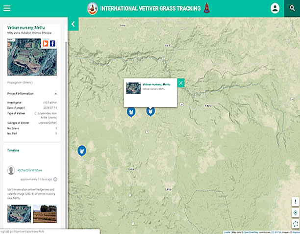
A: Here are some examples. (1) In the Mettu district of Ethiopia there are some 30,000 farmers using vetiver. It is conservatively estimated that at least 50 million vetiver slips have been planted. I located on the map a site that I had visited with a note under "Add Progress" indicating that this site was one of many under the NGO managed program responsible for the development. (2) The Konkan Railway Company in Western India has it on record that it used 9 million vetiver slips to stabilize areas of severe slippage in railway cuts. I just added a single pin to mark the railroad. In the future more exact sites may be identified.
Q: The project summary and charts don't seem to function. Why not?
A: Programming problem will be fixed by developer.
Q: There seem to be some zooming problems with the global map?
A: Zooming works well on both smart phone apps by using standard finger "squeeze" zoom in and out methods. There is a problem with the "computer" app in that it zooms in, but when zooming out the menu also zooms out and becomes very small. Hopefully the developer will fix this.
Q: How can I use the tracking system to monitor my project that consists of many sites and in more than one country?
A: This tracking system should be very helpful in monitoring project progress as vetiver activity locations can be located, recorded and progress added from time to time. With improved data summary access one should be able to summarize total vetiver activity under your project. To make this easier under the "Project Name" field you can add an abbreviation, for example TIP (Tropical Islands Projects), to each site under the project - later you can do a search on TIP and all TIP sites will show in side bar. You can do other "customization" such as adding a country code (use three letter (alpha-3) UN system - listed - see below - to the project name, that might help in sorting. Overall the application search button seems to work alright. It would be very helpful if the application would allow a complete download of all data to an excel spreadsheet, making it possible for a more complete analysis.